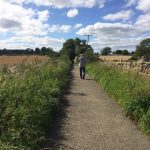
Walking is good for the environment and for people’s health. It can substitute for car journeys, connect people to public transport and reduce pollution. Chalford is a marvellous place to walk. There is a web of small roads and footpaths around our neighbourhoods, all surrounded by magical valleys.
It would be great if everyone walked more, for pleasure, exercise and to get to the shops or doctors. Our 2021 survey asked people what barriers they see to walking. They replied: lack of signage; speed and amount of traffic; poor state of the pavements; mud!

We can’t cure all these with a magic brush but we can make gradual improvements. The Parish Council have done a great deal to make our local footpaths more accessible and safe, and if you have any concerns about a path, get in touch with them (christine@chalford-glos.gov.uk). We are working with the Parish Council to reduce speeds within the parish, ideally with a general 20mph limit. We are also trialling our own maps to help give people confidence to venture further afield.
We’d like to undertake other projects such as: guided educational or history walks, walking races or challenges, sponsored events, school walking buses, new paved paths and shortcuts, better lighting and signage.
We can’t do all this ourselves – it’s too big. If you can help then contact us: info@chalcan.org
Footpath Maps
We are building a collection of footpath maps to help you explore the area. It’a a bit of a trial – please leave some feedback (info@chalcan.org.uk) and if they’re useful recommend them to others and we’ll do some more! Click on one of the areas below to find a map and description. For each one you’ll find a PDF version that you can download and print and also a GPX file which you can open with appropriate apps (instructions here)
ChalCAN’s Biodiversity Action has created a circular Wildlife Trail 12 km long through Chalford Parish. Funded by Caring for the Cotswolds, in collaboration with Chalford Parish Council. You can see the trail and download the map here
Before you go…
- Check the weather
- Wear suitable clothes and footwear – beware mud!
- Understand the countryside code
- If you’re taking a dog make sure you keep it under control: farmers are understandably concerned about livestock (see Blue Cross advice) and please do pick up and take home their poo.
- Gear up for a great time then give us some feedback on the maps online or to info@chalcan.org.uk
Click on a walk below to see the route
For a longer walk why not try the Walk Around Stroud – a 10 mile route around the town boundaries on public footpaths. Amazing views all the way. There’s a pdf here and you can pick up a paper copy at the Town Information Centre.