Wildlife Trails
Discover the wildlife in and around Chalford with our downloadable map..
Image: Jonathan Buckley
Biodiversity Trail
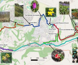
ChalCAN’s Biodiversity Action has created a circular wildlife trail 12 km long through Chalford Parish. We’ve been funded by Caring for the Cotswolds, in collaboration with Chalford Parish Council.
It passes through some of our wonderful Local Wildlife Sites and also places where the community have worked to improve biodiversity. There are information boards at Abnash Bank, France Lynch Pleasure Ground, Parish Bank, Middle Hill Spinney and Meadow, and Frith Wood. We hope that both residents and visitors will enjoy following the trail.
Using the trail downloads
The trail is available for downloading in PDF, GPS and KML file types. The GPS and KML formats enable you to experience an interactive map – whereby you can track your position on the trail using apps such as Google Maps and Google Earth. For more detailed instructions on downloading and installing these files click here
In addition, recently launched, are an amazing set of walks around Chalford. Great for those autumn rambles. All available as pdfs to download and print or gps to download onto suitable phone apps. Go to https://chalcan.org.uk/walking-2
Accessibility
This is a traditional Cotswold landscape with steep hillsides. Most of the Trail is on public rights-of-way, public roads or lanes with/without pavements. Other parts are on footpaths through fields and woods with stiles/kissing gates. Some of these parts are very steep and uneven. The Trail has been divided into sections-each section has a different designated colour on the map. Please see the downloadable map and leaflet (below) for full information.

PDF Leaflets
Map of the trail (PDF 1.4 MB)
View PDF Here
View the trail and find out about the local plants you can see on your walk (PDF 1.8 MB)
View PDF Here
